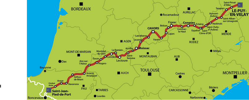

Le chemin de Compostelle (sur la voie du Puy en Velay) compte 32 étapes et 754klm pour 32 jours de marche, sans compter les jours de pause.
Il s’agit du chemin de Compostelle le plus fréquenté, sur les quatre grande axes. Pour l’avoir déjà réalisé, il est particulièrement bien balisé, et vous y trouverez des hébergements, et de quoi vous restaurer, tout au long de la randonnée.
Voici les statistiques du chacune des journées de marche :
| Étape | Départ | Arrivée | Distance (klm) | Durée | Denivelé Positif (m) | Denivelé Negatif (m) | Point Haut (m) | Point Bas (m) | Difficulté | Trace GPS |
|---|---|---|---|---|---|---|---|---|---|---|
| 1 | Le Puy-en-Velay | Saint-Privat-d'Allier | 23.6 | 6h | 548 | 346 | 1214 | 642 | moyenne | http://www.podiensis.com/gpx/Le-Puy-en-Velay-Saint-Privat-Allier.gpx |
| 2 | Saint-Privat-d'Allier | Saugues | 20.2 | 5h | 1042 | 941 | 1103 | 596 | difficile | http://www.podiensis.com/gpx/Saint-Privat-Allier-Saugues.gpx |
| 3 | Saugues | Le Sauvage | 19.4 | 4h45 | 563 | 230 | 1326 | 927 | difficile | http://www.podiensis.com/gpx/Saugues-Le-Sauvage.gpx |
| 4 | Le Sauvage | Aumont-Aubrac | 28.1 | 7h | 590 | 828 | 1348 | 921 | moyene | http://www.podiensis.com/gpx/Le-Sauvage-Aumont-Aubrac.gpx |
| 5 | Aumont-Aubrac | Nasbinals | 27.5 | 7h | 442 | 324 | 1254 | 1015 | moyenne | http://www.podiensis.com/gpx/Aumont-Aubrac-Nasbinals.gpx |
| 6 | Nasbinals | Saint-Chély-d'Aubrac | 16.5 | 4h | 301 | 679 | 1372 | 798 | moyenne | http://www.podiensis.com/gpx/Nasbinals-Saint-Chely-Aubrac.gpx |
| 7 | Saint-Chély-d'Aubrac | Espalion | 24.4 | 6h | 673 | 1125 | 926 | 335 | moyenne | http://www.podiensis.com/gpx/Saint-Chely-Aubrac-Espalion.gpx |
| 8 | Espalion | Estaing | 12.2 | 3h | 365 | 390 | 493 | 321 | moyenne | http://www.podiensis.com/gpx/Espalion-Estaing.gpx |
| 9 | Estaing | Golinhac | 14.1 | 3h30 | 819 | 481 | 678 | 318 | moyenne | http://www.podiensis.com/gpx/Estaing-Golinhac.gpx |
| 10 | Golinhac | Conques | 21.2 | 5h15 | 579 | 967 | 677 | 271 | moyenne | http://www.podiensis.com/gpx/Golinhac-Conques.gpx |
| 11 | Conques | Livinhac-le-Haut | 26.6 | 6h45 | 1218 | 1289 | 588 | 181 | difficile | http://www.podiensis.com/gpx/Conques-Livinhac-le-Haut.gpx |
| 12 | Livinhac-le-Haut | Figeac | 25.6 | 6h30 | 639 | 639 | 428 | 187 | moyenne | http://www.podiensis.com/gpx/Livinhac-le-Haut-Figeac.gpx |
| 13 | Figeac | Cajarc | 31.5 | 8h | 730 | 780 | 393 | 150 | difficile | http://www.podiensis.com/gpx/Figeac-Cajarc.gpx |
| 14 | Cajarc | Limogne-en-Quercy | 17.4 | 4h15 | 427 | 268 | 373 | 146 | moyenne | http://www.podiensis.com/gpx/Cajarc-Limogne-en-Quercy.gpx |
| 15 | Limogne-en-Quercy | Mas-de-Vers | 21.5 | 5h30 | 181 | 216 | 330 | 266 | moyenne | http://www.podiensis.com/gpx/Limogne-en-Quercy-Mas-de-Vers.gpx |
| 16 | Mas-de-Vers | Cahors | 18.9 | 4h45 | 296 | 455 | 283 | 115 | moyenne | http://www.podiensis.com/gpx/Mas-de-Vers-Cahors.gpx |
| 17 | Cahors | Montcuq | 31.8 | 8h | 613 | 543 | 303 | 113 | difficile | http://www.podiensis.com/gpx/Cahors-Montcuq.gpx |
| 18 | Moncuq | Lauzerte | 15 | 3h45 | 446 | 437 | 259 | 123 | moyenne | http://www.podiensis.com/gpx/Moncuq-Lauzerte.gpx |
| 19 | Lauzerte | Moissac | 26.8 | 6h45 | 502 | 615 | 227 | 72 | moyenne | http://www.podiensis.com/gpx/Lauzerte-Moissac.gpx |
| 20 | Moissac | Auvillar | 21.3 | 5h30 | 109 | 72 | 122 | 57 | facile | http://www.podiensis.com/gpx/Moissac-Auvillar.gpx |
| 21 | Auvillar | Lectoure | 32.8 | 8h15 | 577 | 512 | 213 | 65 | difficile | http://www.podiensis.com/gpx/Auvillar-Lectoure.gpx |
| 22 | Lectoure | La Romieu | 19 | 4h45 | 284 | 279 | 219 | 78 | moyenne | http://www.podiensis.com/gpx/Lectoure-La-Romieu.gpx |
| 23 | La Romieu | Condom | 12.9 | 3h15 | 203 | 302 | 214 | 80 | facile | http://www.podiensis.com/gpx/La-Romieu-Condom.gpx |
| 24 | Condom | Eauze | 35.3 | 7h45 | 448 | 370 | 178 | 73 | difficile | http://www.podiensis.com/gpx/Condom-Eauze.gpx |
| 25 | Eauze | Nogaro | 20.7 | 5h15 | 232 | 293 | 182 | 95 | moyenne | http://www.podiensis.com/gpx/Eauze-Nogaro.gpx |
| 26 | Nogaro | Aire-sur-l'Adour | 28.2 | 7h | 325 | 256 | 163 | 80 | moyenne | http://www.podiensis.com/gpx/Nogaro-Aire-sur-Adour.gpx |
| 27 | Aire-sur-l Adour | Arzacq-Arraziguet | 33.5 | 8h15 | 476 | 324 | 235 | 83 | moyenne | http://www.podiensis.com/gpx/Aire-sur-Adour-Arzacq-Arraziguet.gpx |
| 28 | Arzacq-Arraziguet | Arthez-de-Béarn | 30.4 | 7h30 | 473 | 502 | 246 | 103 | moyenne | http://www.podiensis.com/gpx/Arzacq-Arraziguet-Arthez-de-Bearn.gpx |
| 29 | Arthez-de-Béarn | Navarrenx | 31.8 | 8h | 543 | 619 | 259 | 75 | moyenne | http://www.podiensis.com/gpx/Arthez-de-Bearn-Navarrenx.gpx |
| 30 | Navarrenx | Aroue | 20.2 | 5h | 299 | 304 | 190 | 97 | moyenne | http://www.podiensis.com/gpx/Navarrenx-Aroue.gpx |
| 31 | Aroue | Ostabat-Asme | 24.2 | 6h | 662 | 634 | 292 | 68 | moyenne | http://www.podiensis.com/gpx/Aroue-Ostabat-Asme.gpx |
| 32 | Ostabat-Asme | St-Jean-Pied-de-Port | 22.2 | 5h30 | 476 | 425 | 273 | 138 | moyenne | http://www.podiensis.com/gpx/Ostabat-Asme-Saint-Jean-Pied-de-Port.gpx |